

2D Seismic Acquisition Survey
Overview
UIL Energy Ltd proposes to conduct a 2D seismic survey within exploration permits 447, 488 and 489 near the town of Badgingarra (Shire of Dandaragan).
The proposal would involve clearing of up to 24 hectares of native vegetation within a proposal area of 101,813 hectares. Clearing will occur within Badgingarra National Park, Wongonderrah and Twyata Nature Reserve, unallocated Crown Land, road reserves, and private properties.
Why your views matter
At this initial stage of the EIA process, comment is simply sought on whether or not the EPA should assess a proposal and, if so, what level of assessment is considered appropriate.
The following diagram shows the stage this referral is at:
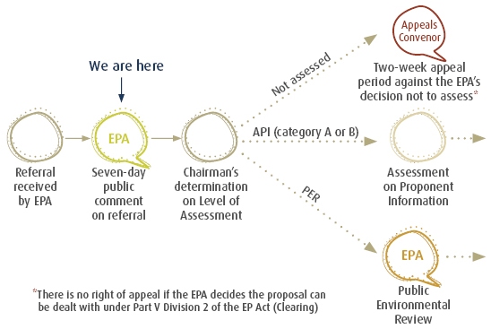
What happens next
Following the seven day public comment period and consideration of any comments received, the EPA will decide whether or not this proposal requires environmental impact assessment and, if so, what level of assessment will be applied.
The Chairman's decisions on level of assessment are released each Monday on the EPA's website.
Areas
- All of Western Australia
Audiences
- Public
Interests
- Seven-day comment on referrals
Share
Share on Twitter Share on Facebook